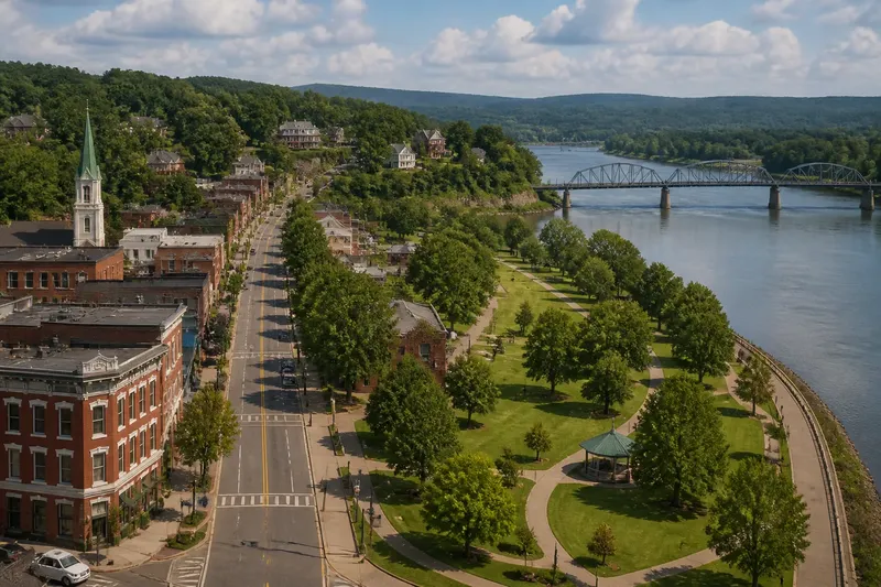
Main Street or Riverfront? Two Ways to Read a Town
A Main Street or riverfront walk can reveal different layers of a town. Use these simple observation cues to notice routes, buildings, and daily life.
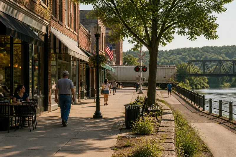
On a Main Street or riverfront walk, the clues can seem to disagree: the busiest storefronts face inland, while the water’s edge looks quiet or fenced off. That is not a failed outing. The two routes often preserve different parts of a town’s life, and a few deliberate observations can make the contrast legible without turning a stroll into a research assignment.
Start with one question: what does each route make easy to see, reach, or move? Main Street tends to show public-facing commerce and civic routines. A riverfront may reveal transport, work, flood adaptation, recreation, or a boundary between town and landscape. These are tendencies, not a template. The useful evidence is what is actually present: a loading door, a cross street, a retaining wall, a bus stop, a gap in the buildings.
Why does Main Street seem to tell the whole story?
The principal street usually presents the town at eye level. Shop windows, signs, sidewalks, public buildings, and storefront entrances are arranged for people arriving on foot or by road. Even a quiet block offers clues about which services remain visible and where residents can stop without a particular appointment.
That legibility can be misleading. A visitor may treat the most polished block as the town’s center in every sense, though it may be only the best-maintained public face. Look at what the street connects, not just what it displays. Does it lead toward a courthouse square, a school, a residential neighborhood, a highway, or a bridge? Which side has continuous sidewalks, shade, benches, or curb cuts? A route’s practical conveniences tell you who it is easy for and where it expects them to go.
Notice the less photogenic details too. A narrow service lane, rear entrance, delivery bay, or blank wall can mark how businesses function beyond their storefronts. A change in pavement or building height may signal a shift from shops to offices or homes. Do not infer the whole cause from one feature; record the feature first and leave the explanation open.
Why can the riverfront feel separate from town?
Water is a visible landmark, but access to it may be limited. A steep bank, rail line, bridge approach, flood wall, industrial parcel, or private property can interrupt the apparent connection between downtown and river. From the sidewalk, the river may look close. On foot, a safe public route may be a different matter.
Where access is public, the edge may serve a different audience or schedule from Main Street. A boat ramp, park path, landing, fishing spot, or open lawn suggests particular ways of spending time there. A closed gate or working facility also tells you something, though not necessarily why it is closed. Avoid treating water’s presence as proof that the town’s early commerce centered on it. That question calls for local sources, not a confident guess based on a view.
Read the bank as a working boundary. Look for changes in slope, paving, vegetation, drainage, and barriers. These features show how people have shaped movement between land and water. They may also reflect practical demands such as erosion control, flood management, or access for equipment. The visible clue is worth noting; its exact purpose may not be obvious from the path.
How can a Main Street or riverfront walk become easier to read?
Use the same small set of observations on both routes. That prevents the comparison from becoming “shops versus scenery,” which is a tidy contrast but a poor way to notice a town. For each stretch, record what moves, what stops, what invites a pause, and what blocks a route.
- Connections: Note streets, paths, bridges, crossings, and transit stops. Ask where each route leads next.
- Access: Look for sidewalks, ramps, public entrances, gates, fences, and signs. Distinguish a visible destination from one you can reach.
- Work: Notice loading areas, workshops, utility structures, boat facilities, and service entrances. These can reveal activity that the main view hides.
- Public life: Observe benches, shade, gathering areas, storefront seating, and places where people can wait without blocking a passage.
- Edges: Mark abrupt shifts in building use, pavement, elevation, vegetation, or street width. A boundary often says as much as a landmark.
- Signs of change: Look for vacant storefronts, new construction, reused buildings, repaired paths, or spaces with mixed uses. Describe what is there before deciding what it means.
Say you reach a block where a café faces Main Street, but the street ends at a rail crossing before the river. You could note the café as a public stop, the crossing as a break in the route, and the river as nearby but not directly accessible from that point. The likely next move is to look for a signed public crossing or a mapped river access point, rather than assume the gap is a historic divide. The observation stays useful even if the reason for the layout remains unknown.
What should you do when the clues do not line up?
A self-guided walk often produces puzzles. The point is not to solve each one on the spot. Use a simple order: describe the feature, compare it with the other route, then check a reliable local source if the explanation matters.
What if Main Street is busy but the riverfront is empty?
Note the difference in activity and the conditions around each route: shade, access, visible amenities, traffic, and opening hours. A quiet edge may be difficult to reach or simply serve a different purpose; the walk alone cannot settle which.
What if the riverfront is active but downtown looks quiet?
Record what the riverfront supports, such as walking, boating, or work, and note the hours and facilities you can see. Then look for the streets linking it to the town center; activity at one point does not establish that the two routes share the same daily users.
What if a wall or fence blocks the route?
Treat it as a real limit, not a puzzle to bypass. Mark where public access ends and look for a signed alternative on a map or municipal trail page; do not enter private or restricted property for a better view.
What if you cannot tell whether a building is old or reused?
Separate visible details from dates: describe the materials, shape, alterations, and current use. If the building’s history matters, check a local historical society, library collection, or official town record rather than dating it by appearance alone.
Which route should you walk first?
Choose the route that gives you a useful starting point. If you are unfamiliar with the town, Main Street may make it easier to find public entrances, a map, or an open place to pause. If you already know the center, a public river path can show how the town meets its landscape. When the routes connect safely, walk both and compare the same observations rather than trying to rank one as more authentic.
Before setting out, check a local map for public paths, bridge crossings, and access restrictions. In a Southern town, heat, rain, uneven pavement, and changing river levels can affect a walk; choose footwear and timing accordingly, and stay on marked public routes. A useful note can be brief: “continuous shops, two side streets, river path behind flood wall.” That is more dependable than a grand theory built from one attractive view.
A Main Street or riverfront walk is most revealing when it leaves room for uncertainty. Write down the route, the barrier, the open door, or the missing connection, then see whether the same pattern appears elsewhere in town. The next block may explain the first one—or complicate it, which is often how places keep their character.